Hauptstraße 10, 34593 Knüllwald, DEU
51.00334, 9.47038Master Data
Basic information of the location including address components and coordinates
Flood Risk
Location-specific flood risk classification
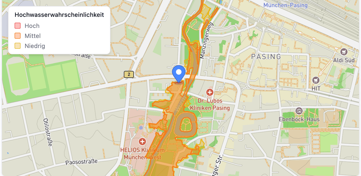
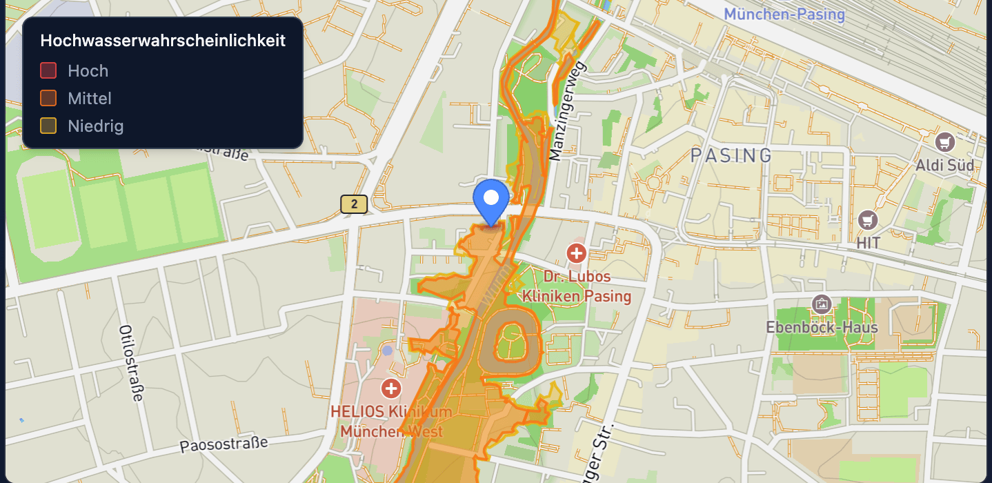
Example data — contact sales for flood risk data on this address
Water Protection Zones
Location-specific identification of drinking and mineral water protection areas


Example data — contact sales for protection zone data on this address
Fire Risks Nearby
Businesses with fire-relevant operations within range of this address
1 low risk near this address
Closest fire risk: 410m
Summary — contact sales for full list with locations and industries
Organizations at this Address
Companies registered at or near this location
3 nearby organizations
Retail sale of pharmaceutical products
Manufacture of lifting and handling equipment
Age Structure
Municipality · Knüllwald
Residents Under 3
2.69
2023
+0.19vs. 2022
1995–2023 · 29 years
Fertility and Mortality
District · Schwalm-Eder-Kreis
Births Young Mothers
4.62
2023
−2.67vs. 2022
1995–2023 · 29 years
Household Structure
Municipality · Knüllwald
Households With Children
31.1%
2023
+1.24 ppvs. 2022
2001–2023 · 23 years
Natural Population Movements
Municipality · Knüllwald
Deaths
11.21
2023
−3.34vs. 2022
1995–2023 · 29 years
Population Development
Municipality · Knüllwald
Population Dev 10 Years
0.36
2023
+1.48vs. 2022
1995–2023 · 29 years
Population Migrations
District · Schwalm-Eder-Kreis
Total Migration Balance
11.69
2023
−9.01vs. 2022
1995–2023 · 29 years
Population Projections
District · Schwalm-Eder-Kreis
Projected Population Dev 2022 2030
-2.12
2024
Population Structure
District · Schwalm-Eder-Kreis
Proportion Foreigners
9.86
2023
+0.92vs. 2022
1995–2023 · 29 years
Atypical Employment
Municipality · Knüllwald
Minijobs Pct Among Marginally Employed
62.1%
2023
−0.04 ppvs. 2022
2018–2023 · 6 years
Economic and Occupational Sectors
District · Schwalm-Eder-Kreis
Employees Construction Industry
5.44
2023
+0.05vs. 2022
2000–2023 · 24 years
Employment rate
Municipality · Knüllwald
Employment Rate
65.4%
2023
−0.34 ppvs. 2022
2001–2023 · 23 years
Employment Structure
District · Schwalm-Eder-Kreis
Supplementary Earners
17.48
2023
−2.56vs. 2022
1995–2023 · 29 years
Unemployment rate
District · Schwalm-Eder-Kreis
Unemployment Rate
4.4%
2023
+0.65 ppvs. 2022
1998–2023 · 26 years
Unemployment Structure
Municipality · Knüllwald
Long Term Unemployed
15.38
2023
−1.5vs. 2022
1998–2023 · 26 years
Earnings and Private Debts
District · Schwalm-Eder-Kreis
Self Employed In Insolvencies
18.83
2023
−3.95vs. 2022
2000–2023 · 24 years
Median income
District · Schwalm-Eder-Kreis
Median Income Full Time Employees
3,491
2023
+121vs. 2022
2000–2023 · 24 years
Purchasing Power
Municipality · Knüllwald
High Income Households
30.3%
2023
+1.71 ppvs. 2022
2013–2023 · 11 years
Economic and Labor Market Function
Municipality · Knüllwald
Outbound Commuters
1,555
2023
+21vs. 2022
1997–2023 · 27 years
Economic Performance
District · Schwalm-Eder-Kreis
Large Enterprises
0.4%
2023
−0.01 ppvs. 2022
1995–2023 · 29 years
Tourism
District · Schwalm-Eder-Kreis
Foreign Guests
9.1%
2023
+1.35 ppvs. 2022
1995–2023 · 29 years
Finances of the Municipalities
District · Schwalm-Eder-Kreis
Municipal Debts Per Inhabitant
2,831
2023
+63.76vs. 2022
2006–2023 · 18 years
Public Finances
Municipality · Knüllwald
Tax Revenues Per Inhabitant
1,360
2023
+103vs. 2022
1995–2023 · 29 years
Household groups
Municipality · Knüllwald
Single Person Households
50.8%
2022
−7.74 ppvs. 2021
2021–2022 · 2 years
Public Administration Function
Municipality · Knüllwald
Tax Offices
0
2024
2017–2024 · 8 years
Recipient of services
District · Schwalm-Eder-Kreis
Female Basic Security
54.8%
2023
+0.36 ppvs. 2022
1995–2023 · 29 years
Transfer payments
District · Schwalm-Eder-Kreis
Alg Ii Benefits Sgbii
42.09
2023
+2.11vs. 2022
2006–2023 · 18 years
Course Offerings
Municipality · Knüllwald
Students Per 1000 Inhabitants
0 /1.000
2023
0vs. 2022
2006–2023 · 18 years
Educational Supply and Cultural Function
Municipality · Knüllwald
Pools
4
2024
2006–2024 · 19 years
School Education
District · Schwalm-Eder-Kreis
Foreign Students
14.3%
2023
+1.44 ppvs. 2022
1995–2023 · 29 years
Training Offer
District · Schwalm-Eder-Kreis
Apprenticeship Positions Per 100 Applicants
103
2024
+1.12vs. 2023
1995–2024 · 30 years
Medical Care
Municipality · Knüllwald
Pharmacies Total
1
2024
0vs. 2023
2015–2024 · 10 years
Social Care
District · Schwalm-Eder-Kreis
Childcare Rate Toddlers
37.9%
2023
+3.37 ppvs. 2022
2003–2023 · 20 years
Building and Housing Stock
Municipality · Knüllwald
Single Two Family Houses
94.97
2023
+0.01vs. 2022
2011–2023 · 13 years
Construction and Rental Prices
District · Schwalm-Eder-Kreis
Offer Rental Prices
7
2024
0vs. 2023
1995–2024 · 30 years
Land Market and Construction Activity
Municipality · Knüllwald
New Single Family Houses
100
2023
0vs. 2022
1996–2023 · 28 years
Environment
District · Schwalm-Eder-Kreis
Household Bulky Waste
33.9%
2023
−0.63 ppvs. 2022
1995–2023 · 29 years
Framework Data Central Places
Municipality · Knüllwald
Total Land Area Sq Km
101
2023
0vs. 2022
1995–2023 · 29 years
Land Use
Municipality · Knüllwald
Recreational Area
0.4%
2023
0 ppvs. 2022
2016–2023 · 8 years
Settlement Structure
Municipality · Knüllwald
Population Medium Centers
0
2023
0vs. 2022
1996–2023 · 19 years
Accessibility
Municipality · Knüllwald
Accessibility Airports
70.93
2024
Commuters
Municipality · Knüllwald
Out Commuters
84%
2023
+0.5 ppvs. 2022
1997–2023 · 27 years
Road Traffic Accidents
Municipality · Knüllwald
Road Traffic Accidents
1,278
2023
−563vs. 2022
2008–2023 · 16 years
Traffic and Communication Function
Municipality · Knüllwald
Total Post Offices
1
2024
Vehicle Inventory
District · Schwalm-Eder-Kreis
Passenger Car Diesel
30
2024
−0.66vs. 2023
1995–2024 · 30 years
Safety
District · Schwalm-Eder-Kreis
Criminal Offenses Per 100k
3,789
2022
+207vs. 2021
2017–2022 · 6 years
Federal Elections
District · Schwalm-Eder-Kreis
Vote Share AfD
23.5%
2025
+12.8 ppvs. 2021
1998–2025 · 8 years
Spatially Effective Means
District · Schwalm-Eder-Kreis
Labor Market Assistance Short Term
1,825
2022
+31.1vs. 2021
2019–2022 · 4 years
Hauptstraße 10, 34593 Knüllwald, DEU
51.00334, 9.47038
Hauptstraße 10, 34593 Knüllwald, DEU
51.00334, 9.47038
The information on this page is sourced from public sources, official registries, or provided by third-party providers. Fusionbase does not guarantee the accuracy, completeness, or timeliness of the data. If you have any questions or suggestions, feel free to contact us via the contact form.